45°08'59"N 001°28'28"E
runway: 14/32 - 1400x30m/4593x98ft - asphalt (CLOSED)
runway: 14/32 - 850x50m - grass (CLOSED)
Brive-La Roche air field (French: Aérodrome de Brive-Laroche, ICAO: LFBV) was an airfield 410 kilometers south of Paris.
The airfield was opened in October 1938.
After World War II the airfield had a single grass runway: 02/20 at ca. 600meters. A second, longer runway (14/32 at ca. 1400meters) was added before 1959. A 600m asphalt runway was laid out parallel tot the grass 14/32 in 1969.
Brive-LaRoche seen in June 1950 with a single grass runway oriented 02/20, a location marker and a parachute circle (IGN, via
Géoportail).
By 1959, the airfield had gained a second hangar and a second, larger runway, oriented 14/32 (IGN, via
Géoportail).
Runway markers and airfield drainage can be clearly seen in this 1961 aerial photo (IGN, via
Géoportail).
Brive-La Roche shortly after its 600m runway was completed in 1969 (IGN, via
Géoportail).
By 2001 the airfield was completely built in by the surrounding towns (IGN, via
Géoportail)

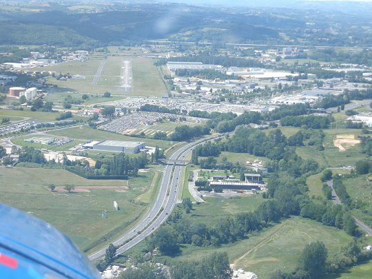
On approach to Brive in 2008 (
d140.fr)
2009 map with the position of the airfield (via
hebels.nl)

2009 Chart indicating the position of the airfield (
Navigeo.org).
Brive-La Roche was replaced by an all new airfield: Brive-Souillac, located 10 kilometers/6 miles to the south. As a result of the new airport, Brive-La Roche closed on 15 June 2010. The airfield then spent years in disuse, awaiting a decision on its future development.

Brive-La Roche in the summer of 2011 with large white X's painted on its runways (used with express permission of Olivier Soulié,
brivemag.fr).
In 2016, the platform and surrounding buildings were torn down and built over with a new commercial zone. The runways and taxitrack remained intact until at least the end of 2016, but the large white Xs on the runway had faded.
Photos shot at the airport in 2012 can be viewed at flight-report.com
 Brive-La Roche


