 Cambrai-Niergnies
Validation date: 17 09 2013
Updated on: Never
Views: 8088
See on the interactive map:
50°08'08"N 003°15'53"E
runway: 08/26 - 900x..m/3,000x..feet - Asphalt
runway: 08/26 - 900x..m - Grass
runway: 08/26 - 1,600x75m/5000x..feet - concrete (CLOSED)
runway: 17/35 - 2400x75m - concrete (CLOSED)
Air field Cambrai-Niergnies (Aèrodrome de Cambrai-Niergnies, also known as ALG A-74, ICAO: LFYG) is an airfield 3 miles southeast of Cambrai, in Nord-Pas de Calais, France
The airfield was built as a civilian airport before World War II, consisting of a terminal, hangar, some support buildings and a grass airfield.
It was seized early by the Germans during the Battle of France, and used as a fighter airfield by Jagdgeschwader (JG) 3 against the French Army and the British Expeditionary Force. After the battle was over, the Germans did not use the airfield for several years. In 1943 the Germans began building up the airfield, giving it two 1600meter all-weather concrete runways, oriented 15/33 and 09/26, and a large number of dispersals, hangars and other facilities. Of course a target of this magnitude could not be ignored by the USAAF who sent the Ninth Air Force. They attacked the airfield on 1st and 2d December 1943 with B-26 Marauder medium bombers (322d, 387th Bombardment Groups), servery damaging the facility. The damage was so extensive the Germans did not use the airfield again.
Cambrai-Niergnies airfield photographed in January 1940 (IGN.fr)
By early September the US 9th Army captured the base, and they ordered the IX Engineer Command 862d Engineer Aviation Battalion to make the airfield fit for air operations. Within two days they had the bomb craters filled, laid PSP on the 15/33 runway, and patched up the 08/26 runway with asphalt. A tent city was set up to support the facility, an access road was built, electricity made available and a dump for fuel, ammunition, supplies and drinkable water set up. Designated ALG 'A-74 Cambrai/Niergnies Airfield' it was ready for operations on 12 September 1944. The first two weeks it was used by P-47s of the 48th Fighter Group, from October until 2 May 1945 it was home to B-26 medium bombers of the 394th Bomb Group (Ninth Air Force). The airfield was handed over to the French Air Ministry on 30 June 1945.
A 1946 French map of Cambrai-Niergnies airfield.
The north side of an abandoned Cambrai-Niergnies airfield, photographed in October 1947, two years after the end of World War II.(IGN.fr)
For years the French left the base as it was. Many unexploded munitions and wrecks of Allied and German aircraft littered the airfield and most of the buildings were in ruins.
Lacking the money to restore the airfield, the Air Ministry leased the entire land to local farmers, after first removing the dangerous munitions.
By 1950 the airfield was offered to the USAF as part of their NATO commitment to establlish a modern airbase to counter the threat of the Cold War and the Soviet Union.
It was decided to build up the air base as a "bare bones" facility with minimal facilities to dispeerse aircraft in case of war. From 1953 French demolition and construction companies began to remove German structures and wreckage from the old airbase. French EOD teams began clearing the remaining unexploded munitions and a modern all weather NATO jet-capable runway was laid over one of the former German runways, aligned 15/33. The other runway was totally refurbished and taxiways and dispersals were built. One taxiway was built parallel to the main runway at the same length, so it could double as an emergency runway. When completed the resulting air base had enough room to accommodate up to 4 squadrons of aircraft.
The air base was never used however, apart from an occasional touch and go by NATO (mostly USAF) aircraft. When the French decided to withdraw from the military branch of NATO in the late 1960s, the base was abandoned.
Cambrai-Niergnies while under redevelopment on 25 May 1953. Even at this early stage, the airfield had one active runway already: the eastern half of the 08/26 already had runway markers and a displaced treshold applied to it (merged from photos found at IGN.fr).
Cambrai-Niergnies in late April 1955. The airfield had 12 QRA positions on the south side of the main runway and another 16 on the north side. Additionally, at least 10 hangars are visible in the original photo, 3 west, 3 northeast and 4 east of the airfield, as well as no less than 40 dispersals (IGN.fr).
When the NATO facility closed, the French Air Ministry loaned the facility to the local government. They converted the airfield into a civilian airfield, and some time after 1970 they added 2 grass runways. By 1983 most of its hangars had been taken down but the concrete runways were still both in use. The use of all runways continued until at least 2000, although by then the main runway had been shortened by moving the northern treshold 800m south.
By 2004 only a small recreational airport remained, with about 3000' of the 5000' 08/26 secondary runway being maintained as the airport's main runway. Parallel to that runway a second grass runway has been built for use by gliders. A small ramp north of the 08/26 runway is connected to the runway by a asphalt taxi track and support buildings appear to be former NATO buildings, but have been extensively upgraded.
The NATO airbase still exists almost intact, although its condition is deteriorating. Joints in the concrete of the runways, taxiways and dispersals are getting filled with vegetation. From the air however the airfield seems frozen in time.
Cambrai-Niergnies airfield after NATO pulled out of France in 1970 (IGN.fr)
Cambrai-Niergnies airfield in 1983, with two extra (grass) runways (IGN.fr)
Cambrai-Niergnies airfield almost unchanged in 1994 (IGN.fr)
Cambrai-Niergnies airfield in 2000. Although it appears one grass runway has disappeared, it is still there, but the grass seems to have dried out (IGN.fr)
the largely abandoned Cambrai-Niergnies airfield in 2004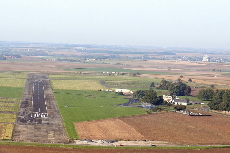
Current runway of Cambrai-Niergnies in October 2008 (Wikipedia).
In 2010 the city of Cambrai bought 320 Hectares of land from the French Ministry of Defence and hired a consultant to consider its options with the land. Ideas that were proposed included a dedicated airfield, areas for reforestation, a golf course, a business area and a photovoltaic site. On 11 October 2010 Cambrai decided on the latter. The German company Enertrag was selected for development of the park, which could extend over 100 hectares and produce the energy needed to heat and light 17 000 inhabitants. Ultimately it should become the largest of its kind in France. The project will represent one million euros in revenues annually for the community.
The conversion of an old NATO base into a "solar farm" is not unique. Similar projects have been considered for Dreux-Senonches, Toul-Rosieres (already completed), Lure-Malbouhans, Marigny le Grand and Marville-Montmédy.
Test
 Cambrai-Niergnies