43°25'00"N 006°44'00"E
runway: 01/19 - 1060x..m/3500feet - Asphalt (CLOSED)
Air field Fréjus (french: Aérodrome de Fréjus-St. Raphael, Base Aérienne Navale (BAN) Fréjus Saint Raphaël or Advanced Landing Ground Y-12 "St. Raphael/Frejus", ICAO: LFTU) was an airfield on the Cote d'Azur.
It was located halfway between Cannes and St.Tropez in southern France and built before World War I as a grass naval airfield. It opened on 28 March 1912 with the first official test flight of a Canard Voisin.
Fréjus continued to be used as an airfield for test flights. For the tests a new unit was established called the CEPA (Commission d'Etudes Pratiques d'Aéronautique or the Commission for the Practical Study of Aviation). The CEPA's mascotte was the head of a Sioux in the shape of a question mark. In its long history of naval aviation, the raid by Roland Garros on 23 September 1913 between Frejus and Bizerte is noteworthy.
During World War I the number of Navy (french: Aeronavale) aircraft grew from about thirty to over a thousand.
The mascotte of the CEPA; a Sioux with a question mark (postedeschoufs.com).
A Loire 50 seaplane at Fréjus (postedeschoufs.com).
After the armistice of the Great War, many flight test centers were closed, but Fréjus remained open. Throughout the 1920s and 1930s Fréjus played a major role in testing new aircraft for the aéronavale. The first expansion of the center occurred in 1923, and by 1924 the airfield consisted of 9 hangars and a starting track for land-based aircraft.
The CEPA participated in the first French aircraft carrier trials in the 1920s. Throughout the 1920s and 1930s multiple land-, sea-, and carrier aircraft types were tested. The second expansion was begun in 1931, growing to 156 hectares, the size it would remain until dissolution in 1995. The bases most memorable hangar (Caquot) was built in 1935.
Carrier trial with Aeronavale in the 1920s (FFAA.net).
Fréjus in 1926 (Photo
IGN, via Rémi Brouillaud)
Frejus ca. 1930, when the focus was primarily on seaplanes
Aerial view of Fréjus looking west in 1939 (postedeschoufs.com).
After the Battle of France in May and June 1940, Frejus was part of Italian-occupied France. Airport operations and the Center were closed by order of Admiral Darlan. Flight operations were restarted as a flying and proficiency school in 1941. The Germans invaded southern France in November 1942 however, and took over the airfield.
On 15 August 1944, United States Army parachute units, including the 4th, 5th and 6th Para battalions, and the lst Indian Army Pathfinders dropped into Southern France between Frejus and Cannes as part of Operation Dragoon. Their objective was to capture the area, destroy all enemy positions and hold the ground until the United States Seventh Army came ashore. Fréjus Airport was seized from the Italian and Nazi-German forces in the area and came under American Control. XII Air Force combat engineers arrived at the airport with the amphibious forces to repair the demolition done by the Germans and the bombings by the Allies. Within 3 weeks they managed to repair the airfield sufficviently to allow combat operations. It was designated as Advanced Landing Ground "Y-12 St. Raphael/Frejus", and became operational again from 8-9 September.
The 79th Fighter Group flew P-47 Thunderbolt combat operations from the airfield against the retreating German and Italian forces from Frejus until mid-October 1944. Once the combat unit moved out, Frejus became a transport airfield, supporting C-47 Skytrain resupply and also casualty evacuation flights until being returned to French control on 20 November 1944.
Bombs drop on Fréjus and its airfield during Operation Dragoon, the Allied invasion of southern France on 15 August 1944. Note the trenches dug accross the airfield by the Germans (461st.org)

The abandoned airfield in June 1945, about a month after the surrender of Germany. The routes to the German built dispersals are clearly visible (IGN, via
Géoportail)
The French Navy reactivated the base on 1 January 1946. CEPA was reactivated 6 months later.
In 1956 an asphalt runway was laid down north-south and Fréjus-St.Raphael became a training and testing facility for the Aeronavale again. Near the end of the 1950s, the units at the base were the Escadrilles (squadrons) 10S, 20S and 58S.

Fréjus airfield with two grass runways, as photographed by IGN in 1949 (Photo
IGN, via Rémi Brouillaud).

Fréjus, August 1955 (IGN, via
Géoportail).

Judging from the scraping of the soil, Fréjus had gotten a hardened runway in late 1956 or early 1957 (IGN, via
Géoportail)
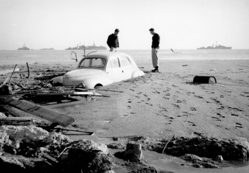
In the evening of 2 December 1959, Fréjus was the scene of a disaster caused by heavy rains in the south of France. The airfield was nearly destroyed when a dam broke at 21:13hrs, causing a 40meter (130ft) high wave which flooded the base 20 minutes later at 70km (45mi) per hour, by which time the water was still 3 meters (10ft) high. 423 people lost their lives and 45 (out of 47!) aircraft were either partially damaged or completely destroyed, including valuable prototypes of aircraft types such as the Breguet Alizé. The flow of 50 million metric cube of mud and water was strong enough to destroy an aircraft parking and wash aircraft out to sea.

When viewed from above it becomes clear what the scale of destruction was that was found on the morning of 3 December. This photo was taken two weeks after the disaster, on 16 December 1959 (IGN, via
Géoportail)

All that was left of the Fréjus helicopter platform after the 2 Dec 1959 disaster (
frejus59.fr).
Aéronavale Broussard semi-buried in the beach that formed during the flooding (
frejus59.fr).
The airbase was rebuilt and remained in service. Through the 1960s, 1970s and 1980s, tests of the Alouette III, Breguet Atlantic, Etendard, Super Frelon, Lynx, Jaguar M and Super Etendard were conducted at the airfield.

This May 1962 photo shows the damage caused y the 1959 flood was restored only two years later (IGN, via
Géoportail)

Many aircraft are visible in this August 1963 photo. In addition to the various military aircraft on the platforms, there are a number of private aircraft near the 19 treshold. Less obvious are 3 aircraft (including what appear to be 2 Lancaster bombers) just east of the 01 treshold (IGN, via
Géoportail).

In this May 1966 photo, two changes are visible. Most obvious, the military had built a proper sportstrack just north of the taxitrack. more subtle is the nearly black asphalt taxitrack to the civilian portion of the airfield (IGN, via
Géoportail).

No significant changes had taken place in this 1968 photo (IGN, via
Géoportail).

A rather surprising change took place around 1970. Although floatplanes and amphibious aircraft had nearly all been replaced with land based aircraft throughout western and southern Europe, the French Aéronavale (navy) had decided to build a seaplane ramp into the Meditteranean Sea at Fréjus Air Base. The ramp (on the right) was completed well before this photo was taken in 1970 (IGN, via
Géoportail).

6 aircraft (which appear to be Dassault Flamants) were dumped on the south side of the arifield in this 1973 photo (IGN, via
Géoportail)

Three things are noticable in this 1975 photo. The most obvious is the expansion of the civilian side of the airfield, between the sportsfield and the 19 treshold. Another is the presence of extra markings on the runway. The third is the presence of two Noratlas aircraft. This is noteworthy, because Fréjus was only home to the sole example of the Nord 2504 maritime patrol version of the Noratlas (IGN, via
Géoportail).

Overview of Fréjus, believed to be in the early 1970s. Notice the Nord 2504 Noratlas (the twin tailed transport-like aircraft behind the hangar) which was unique to Fréjus (
Colleurs de plastique).

The Nord2504 distinguished itself from 'straight' Noratlasses by its retractable radome (visible in the extended position here), a full ASW suite, a turbine generator under its right wing and the two Turbomeca jet engines on it wingtips. It was a flying classroom, carrying a class of 16 students, an instructor and their operations consoles. In this photo it flies along the coast with Fréjus in the background (
FAA.net).
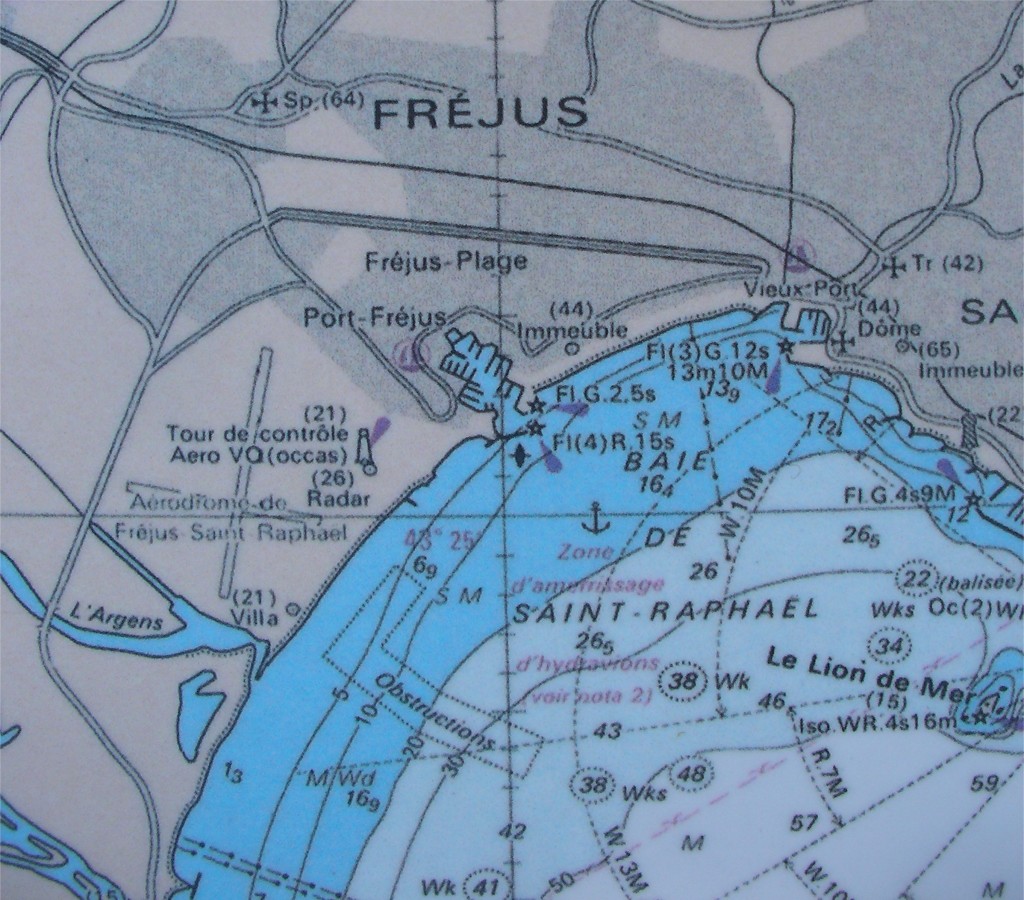
Map of Fréjus with the airfield on the left, just south of the port (
vf-air.com).

This June 1977 photo only shows some light activity on the civilian side of the airfield (IGN, via
Géoportail)

A new taxitrack had been constructed from the 10/28 intersection to the sportsfield by the time this September 1978 photo was shot (IGN, via
Géoportail)

1984 approach chart for Frejus airfield. (SIA, via Olivier from forgottenairfields.com).
In the mid 1980s a reduction in force was announced for Fréjus. The Nord 2504 flying ASW classroom was finally retired on 1 August 1987. On 1 February 1991 the merger of 10S (fixed wing) and 20S (rotary wing) into a single unit took place. Closure of the base was announced in April 1992. The airfield finally closed on 30 June 1995.

The last IGN photo I could find of the active airfield Fréjus was taken in July 1991 (IGN, via
Géoportail).

Frejus, May 1996, a year after the airbase had been closed. the small dots on the centerline of the runway, are in fat small 'x' markings, indicating the airfield is closed. The grass runway received no such markings however (IGN, via
Géoportail).

around the turn of the century, the small 'x' markings were augmented by more visible large 'X' markings. Also, the markings of the grass runway were removed. Most obvious reason was that the whole base was turned into a publicly accessible park (IGN, via
Géoportail)

Aerial view of Fréjus- St.Raphael in 2008. the white X marks on the runway indicate the airfield is permanently closed.
Today the runway and taxiway appear to be in very good condition, but are marked with large white X's to indicate the closure of the air field. Lines of trees was planted on both sides along the runway. The area is now a public park called 'Nature Base Francois Leotard - Fréjus'.

Dassault Étendard IVM '29' of the Aéronavale was parked on the east side of the airfield as a reminder of the Fréjus naval base (2013,
Dick Wools, used with permission).

Part of the Fréjus sea front is this large hangar (2013,
Dick Wools, used with permission).

The Fréjus seaplane ramp, built in 1970, is now part of the beach (2013,
Dick Wools, used with permission).

What appears to be an old control tower on top of the old hangar. A bridge club now occupies part of the offices. (2013,
Dick Wools, used with permission).

The newer control tower on top of the same hangar (2013,
Dick Wools, used with permission).

On 30 July 2014 I passed by the airfield and could not resist to stop and take a few photos of the runway (above) and taxitrack (below). Although both are not immediately ready for use because of rows of trees and a raised bicycle path, they both appear to be in reasonable condition (RonaldV © 2014).

(RonaldV, © 2014)

Dassault Flamand '113' photographed at the site of the former Fréjus aeroclub, now the Fréjus Fire School in 2015 (RonaldV)

The side of the hangar was seen fenced off in the summer of 2015, as parts were falling off the building (RonaldV)

Photo taken roughly halfway along the runway looking northeast towards the town of Fréjus. Although I had planned to walk the full length of the runway, the unusually warm summer of 2015 prevented me from doing so, leaving me to shoot only this photo. It gives a good impression of the current state of the runway nevertheless (RonaldV).
 Fréjus Saint-Raphaël


 Fréjus Saint-Raphaël