 Ollheim
Validation date: 21 12 2013
Updated on: Never
Views: 6718
See on the interactive map:
50°41'34"N 006°52'46"E
Runway: 07/25 - 3000x50m - concrete
Ollheim airfield (Flugplatz Ollheim, also known as Einstazhafen Ollheim, Flugplatz 'Olga' or Advanced Landing Ground Y-59 'Strassfeld') was an airfield 490 km west-southwest of Berlin.
The airfield was tightly connected to Feldflugplatz Odendorf (Odendorf airfield), where Hitler had his headquarters during 'Fall Gelb' (Case Yellow, the invasion of France and the low countries). But where Odendorfs history is fairly well documented, Ollzheims history is less clear.
The airfield was first used in 1940, when Aufklärungsgruppe 31 (AKG 31), flying Focke-Wulf Fw 189A reconnaissance aircraft, were stationed at the airfield to patrol the Franco-German border. After 'Fall Gelb', the unit was moved to Belgium to support the German troops. The only other unit known to have used the airfield was 3. Fallschirmjägerdivision (3 Para Division) in 1943.
During their stay, construction began of a 3 kilometer (3000m) long runway, but nobody seems to know why. Deployment of Messerschmidt Me262 fighterbombers or Arado Ar234 medium bombers, which both required long runways, seem logic, but cannot be confirmed.
A USAAF map of the airfield made in january 1945, depicting the airfield (geocaching.com)
After having been bombed several times, U.S. troops seized the partially destroyed airfield on 5 March 1945. The 820th Engineer Aviation Battallion repaired the airfield, which was completed on 29 March. The airfield was reactivated as Advanced Landing Ground Y-59 'Strassfeld', hosting the 474th Fighter Group of Ninth Air Force with P-38 Lightnings and in april also P-51 Black Widows of 414 and 422 Night Fighter Sqns. After the end of the war, the airfield closed on 10 July 1945. Over the following years, the airfield infrastructure was demolished and the runway was blown up. 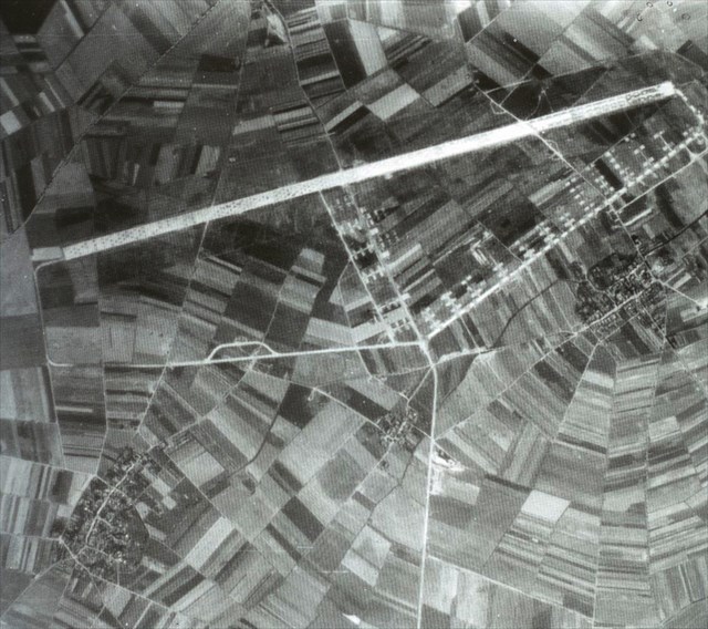
Aerial photo of Ollheim, shot 24 July 1945, 2 weeks after the airfield closed. The USAAF fighter dispersals are clearly visible (via geocaching.com).
The airfield is not completely gone, however. The east side of the runway is now overgrown with trees which were planted in the bombcraters, which even today can easily be found. South of the former airfield, a taxiway existed to the Odendorf airfield. Concrete bridges over small streams still exist, one can be found just east of Mömerzheim for instance.
The area of the former airfield photographed in 2010. The row of trees easily marks the area where the runway once began. It marks about one third of the runway (Google Earth).
 Ollheim