 Orvieto-Castel Viscardo
Validation date: 03 08 2013
Updated on: Never
Views: 6012
See on the interactive map:
42°44'12"N 011°59'47"E
Runway: elliptical airfield area - grass
Orvieto-Castel Viscardo airfield was an airfield 100 kilometers north-northwest of Rome.
It was planned as an emergency landing field in 1927 by the Regia Aeronautica (Royal Italian Air Force) in an area called "Le Prese" close to Orvieto. Back then, emergency airfields were needed to make easy and safe air navigation (which had then many limitations) possible. Changed operational needs led to the planning and construction of a full fledged airfield on the plateau on the border of the towns of Orvieto and Castel Viscardo. Work began in 1936 with the construction of buildings and hangars. The inauguration of the airport, dedicated to “ace” Flavio Torello Baracchini, took place on 27 March 1938.
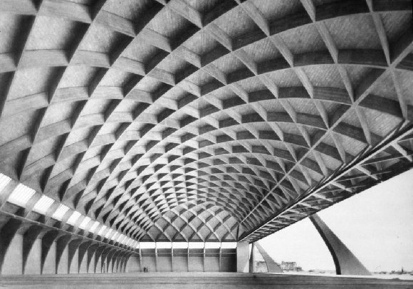
The hangars were built with an innovative, some say even futuristic, technique. If they had not been not destroyed during World War II, they would have offered an amazing visual effect even today. They covered a surface of about 5000 square metres, without internal columns. The front had only three beams, a central pillar supporting a carrier rail and two side pillars that served as door supports. The modern symmetry of the supports and the lightness of the hangar structure made these among the most harmonious built by Nervi and Bartoli. It measured 12 meters high, 102 meters long, and 36 meters in width with an internal area of 3700 square meters.

Overall view of the 1938 airplane hangar (lanternslide.wikispaces.com)
Internal view of “Aviorimessa Nervi-Bartoli” (Structurae.de)
Between 1938 and 1940, the airport hosted the "Pilot School - Phase 2". In 1940 the 12th Terrestrial Bombing Wing, nicknamed "Sorci Verdi", was deployed on the airfield with XLII Gruppo. It consisted of 206 Squadriglia (8 SM-79) and 207 Squadriglia (8 SM-79).
On 18 October 1940 the airport was expanded and two new hangars were built. The Nervi and Bartoli won the contract again and built them in two years with very few differences in construction from the existing ones.
In 1942 the 18th Air Transport Wing with LVI Group (222 and 223 Squadron) and Group LVII (224, 225 and 247 Squadron) were relocated from Perugia airfields to Orvieto.
Throughout the war, the airport was used as a logistic platform to move material and staff to all fronts. In 1943, when the airbases around Rome were subjected to increasing bombardments, many of the aircraft were transferred to Orvieto airfield.
On 9 September 1943, the day after the armistice, the airport was besieged by the German Wehrmacht. It soon became the base of operations for German aviation, but after several bombings of the Allies on 20 and 21 October 1944, the Germans decided to move further north burning aircraft and destroyed all facilities.
Today, just across the road from where the old airport was located, lies the Alfina air strip, home of the Airplane Club Volo Velistico of Castel Viscardo.
This is not the same airfield. The only airport's remains still visible today are the block of the motor pool, the water reservoir and nine sections of the rear pillars of one of the hangars built in1936. (see below in Google Earth- Street View). In the center of the old flying filed is now a small runway, intended for radio controlled scale models.
The outlines of the former airfield (red) and the present day airfield (yellow) in 2003 (Google Earth)